Drought hits ‘exceptional’ levels on Western Slope near wildfires as forecasters remain ‘optimistic’ about long-term outlook in Colorado
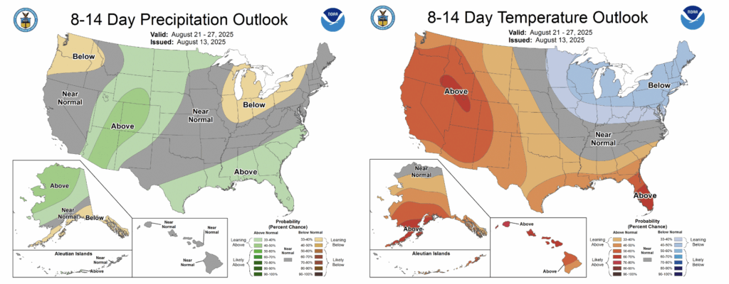
The long-term outlook from the National Oceanic and Atmospheric Administration shows elevated chances for above-average precipitation in Colorado toward the end of August


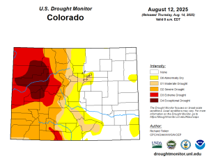
U.S. Drought Monitor/Courtesy illustration
Drought conditions in Colorado continued to worsen this week with the latest U.S. Drought Monitor report detailing “exceptional drought” conditions in the region where the state’s largest wildfires are burning.
Nearly all of Garfield County and a large portion of Rio Blanco County are experiencing “exceptional drought,” the highest level, according to the Drought Monitor report published Thursday.
Multiple large wildfires are burning in Rio Blanco County, where drought conditions are the worst. That includes the Lee Fire, which was burning on 133,800 acres with 12% containment; the Elk Fire, which was burning on 14,500 acres with 93% containment and the Crosho Fire, which was burning on 2,220 acres with no containment as of Friday. The Lee Fire is the fifth largest wildfire in Colorado’s history.
“The multiple wildfires currently burning across western Colorado are evidence that there is stress on vegetation and soils in the drought-afflicted areas,” Colorado Climate Center Climatologist Allie Mazurek wrote in a blog post Thursday.
The “exceptional drought” conditions also extended into parts of Mesa, Pitkin, Delta, Gunnison and Moffat counties. Nearly the entire Western Slope is experiencing “severe drought,” level 2 of 4, or higher, according to the Drought Monitor.
Streamflow along the White River in Meeker, near the Lee and Elk fires, is in the 1st percentile in its 121-year record, and the current flow in the river is “very close to the station’s all-time low record,” Mazurek said. June and July were also ranked in the top ten hottest and driest on record for most of the northwestern region of the state, according to the Colorado Climate Center.
“Poor snowpack during the winter teed up western Colorado for drought headed into summer, and the dry, hot conditions over the past few months have exacerbated conditions,” Mazurek wrote in a blog post Thursday. “These factors have led to the widespread extreme to exceptional conditions.”
National Weather Service forecaster Gillian Felton said that scattered showers were expected Friday and Saturday across the Western Slope, including near the wildfires burning in Rio Blanco County.
But because it is so dry, the small amount of moisture passing through the region may not make it to the ground in areas, Felton said. She noted that the region is expected to dry up by Monday with little chance of precipitation until at least late next week.
“I wouldn’t expect anything significant; we don’t have a super anomalous amount of moisture in the region for these storms,” she said. “It’s not like a huge monsoonal surge of moisture or anything, but there are chances for a good shower here or there.”
Looking ahead, Mazurek said that August through October tends to be the time of year that the Western Slope receives its greatest amounts of precipitation. While this seasonal pattern “does not guarantee ‘drought busting’ precipitation,” she said she is holding out “a little hope” that moisture could return to the region in the coming weeks.
The eight to 14 day precipitation outlook from the National Oceanic and Atmospheric Administration also shows elevated chances for above-average precipitation in Colorado toward the end of the month, although above-average heat is expected to continue through that time period.
“There are a couple reasons to remain optimistic about precipitation in following weeks and months,” Mazurek said. “But many uncertainties remain, and a lot of precipitation will be needed to alleviate drought conditions in western Colorado.”