Relief unlikely for northwest Colorado as conditions continue to heat up and dry out
Could La Nina conditions develop again in winter?

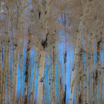
Austin Colbert/The Aspen Times
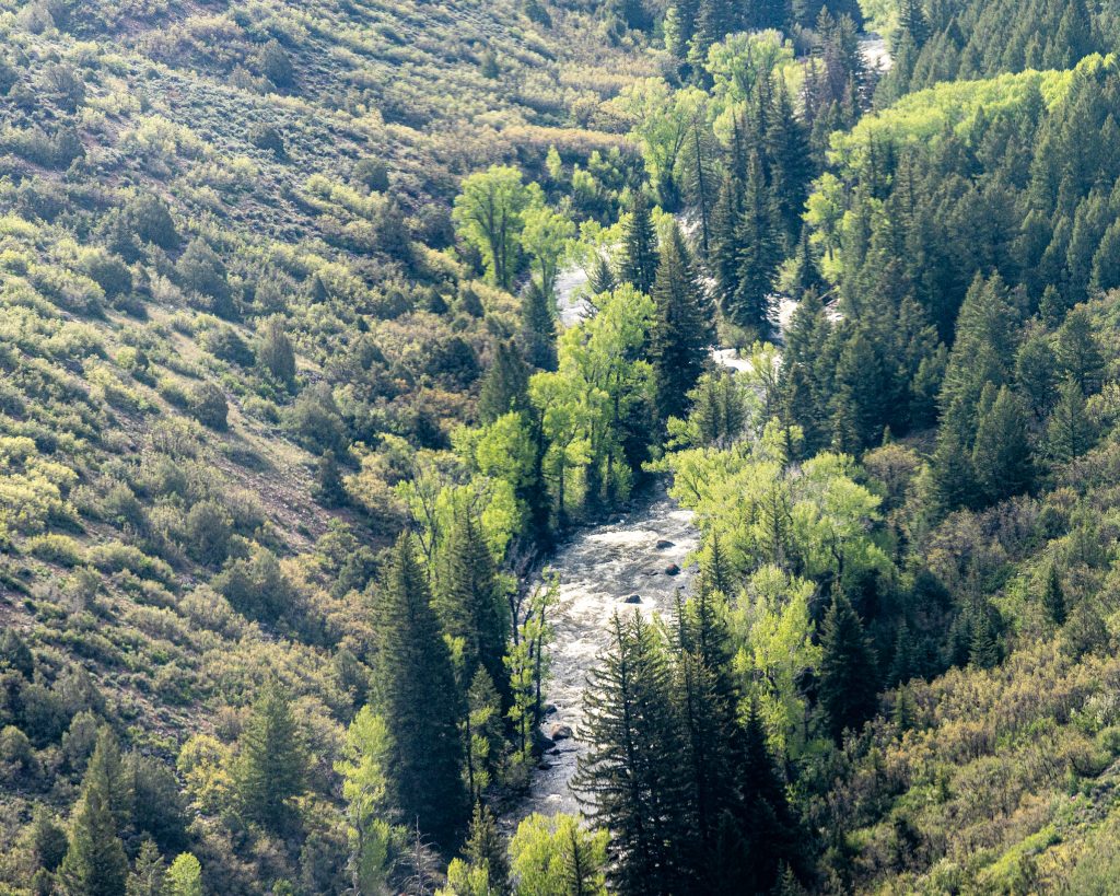
Northwest Colorado is parched.
Following a winter that brought near-normal snowpack, conditions in the region have deteriorated after a period of hot and dry weather. The last few months have led to worsening soil moisture, drought conditions, wildfires and more.
“Conditions (in northwest Colorado) have really made a turn for the worse over the last several months,” said Peter Goble, assistant state climatologist with the Colorado Climate Center, at the July 22 Water Conditions Monitoring Committee meeting.
From a statewide perspective, while many climate factors are near normal, Gable said there have been some clear “winners and losers.”
Throughout Goble’s presentation, he pointed to the state’s northwest corner as a “loser” as a variety of climate factors worsen — including precipitation, temperature, soil moisture and drought. This downward trajectory tracks back to April.
“If we look at the last couple of months, it’s been a little bit warmer and drier than normal statewide, not way out of the ordinary,” Goble said. “Unless you’re looking at really the westernmost counties of the state or the northwest quadrant of the state, where drought conditions have really worsened over the last couple of months.”
Historically, April is among the wettest months for the state, but especially the Western Slope. Statewide, however, the month is on its eighth straight year of having below normal moisture, Goble said.
“This is not necessarily a trend projected by climate models that April would dry out,” he said. “So I suspect that’s more an artifact of climate variability and just the fact that we’ve been on the drier side of normal more than our fair share over the last eight years in that crucial month.”
The impact of a dry April coupled with dry soil moisture led streamflow forecasts to drop significantly from the spring months to June, according to a Colorado River Basin outlook presented at Colorado River District’s July board meeting.
“Basin-wide over that time, forecasts dropped by 21% of average in the Colorado River Headwaters; by 27% of average in the Gunnison basin; and by 43% in the White-Yampa River basin,” according to the written report.
The report also indicated that these conditions led to “decreased runoff efficiencies such that there has been a large gap between peak snowpack and subsequent runoff.”
Nagam Gill, a hydrologist with the Colorado Data Collection Office of the National Resources Conservation Service, shared at the July 22 meeting that observed June streamflow across the state was at 62% of normal. Gill added that reservoir storage looked fairly good, sitting at 91% at the end of June — only 3% below where it sat last year.
The Colorado River District report indicated that while there were “reasonably good storage conditions for this time of year throughout the West Slope,” a few key caveats included Green Mountain Reservoir and Ruedi Reservoir, which were below capacity in the Colorado River basin. Blue Mesa Reservoir in the Gunnison River basin is also not expected to fill.
June continued the trend toward hotter and drier conditions. In certain northwest counties, both the month of June alone and the last three months rank among the top 10 hottest on record. The period of record dates back to 1895.
“The month of June was one of the 10 warmest Junes on record for a good chunk of Moffat, Rio Blanco, and Garfield counties, as well as some other splotches around the west slope,” Goble said, later noting that “ranking much of northwest Colorado for April through June” places it in the top 10 warmest for those three months.
For some counties in the region, this trend extends back even further than this spring.
“The last 12 full months have been the warmest July through June on record through the western portions of Mesa, Garfield, Rio Blanco, and Moffat counties,” Goble said.
At the same time, conditions have continued to dry out this spring and summer. The clear loser in terms of June precipitation was again northwest Colorado, where worsening conditions extend “all the way from Summit County up to that northwestern border,” Goble said.
Gill reported that from the start of the water year (Oct. 1) to July 20, Colorado precipitation is at 85% of normal, compared to 101% during the same period last year. The statewide 30-day precipitation is at 58% of normal compared to 164% last year and the 60-day precipitation is at 77% of normal compared to 121% last year.
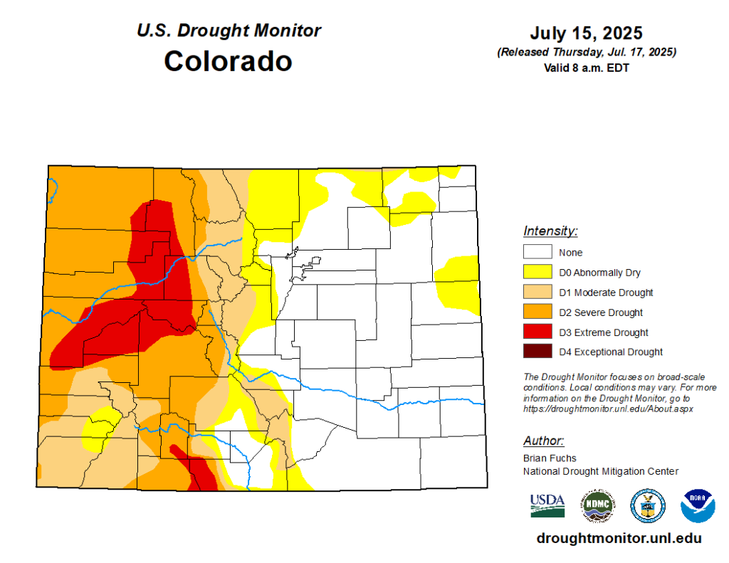
With these hotter and drier conditions, northwest Colorado has seen a significant development of drought conditions. The latest Colorado Drought Monitor from the U.S. Department of Agriculture shows severe drought conditions across much of western Colorado and worse, extreme drought conditions in portions of Mesa, Delta, Pitkin, Eagle, Rio Blanco, Moffat and Garfield counties.
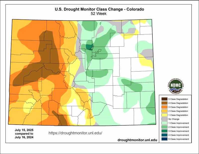
These drought conditions have seen significant degradation in northwest Colorado, not only in the last three months, but in the last year, Goble said. A year ago, much of the severe and extreme drought conditions did not exist, he added.
“This has led to some worsening soil moisture conditions across western Colorado,” Goble said. “So we have portions of Eagle, Garfield, Pitkin, Mesa counties that are looking at soil moisture in the fifth percentile or lower.”
In addition, these conditions have led to a decline in vegetation health as well as an unfavorable water balance, where evaporation is high and precipitation is low. The latter of which has especially impacted areas in Pitkin, Summit and Eagle Counties, Goble said.
Will conditions change as summer transitions to fall?
So far, July has followed this trend of hotter and drier than normal conditions, with the short-term outlook promising little relief as well.
Looking at the seven-day forecast from Tuesday, Goble reported it will be “warm but not entirely dry,” with thunderstorms possible on both Tuesday and Thursday nights in the central Rockies.
As a whole, however, “it does look like it’ll be a drier than normal week more than likely in both western Colorado and southeastern Colorado,” he added.
The National Weather Service Climate Prediction Center’s 8- to 14-day outlook predicts more of the same.
“There’s a good chance more of a kind of true high-pressure ridge will form over the south-central U.S., largely encompassing Colorado, which will likely keep us warmer and drier than normal going into the month of August,” Goble said.
This forecast includes some “possibility of a decent surge of moisture making its way into Colorado,” in the last days of July and first days of August.
“It’s possible we could see some good thunderstorms skirting around the edge of that high-pressure ridge,” Goble said, adding that given the time of year could be a potential for flash flooding in the High Country and Front Range.
While this late summer period can mean monsoon moisture on the Western Slope, it’s unclear what it could bring. The National Integrated Drought Information System forecasts for July through September show equal chances of below-, near-, or above-average monsoon precipitation for the Western U.S.
Could it be another La Nina winter?
While, as Goble put it, most weather prediction models “descend into chaos,” the further into the future you look, he did give some insight into what the winter could bring for Colorado.
Currently, Colorado is in what climatologists call “neutral conditions” — that is, the conditions do not follow either La Nina or El Nino climate patterns.
Colorado is expected to see a continuation of hotter and drier conditions through the next few months, based on the Climate Prediction Center’s long-term predictions.
“Unfortunately, for Colorado, we see an increased probability of above-normal temperatures over the season (August through October), particularly on the West Slope, and then an increased probability of below-normal precipitation for much of the state, with a little bit more confidence the further north that you go,” Goble said.
Neutral conditions are expected to continue through August, but beyond that, there’s uncertainty.
“As we move into, say, September, October, November, there’s a near 50% chance of remaining in neutral and near 50% chance of La Nina redeveloping with a very low probability of El Nino,” Goble said. “If we go forward into winter, we see a similar story.”
La Nina typically brings more precipitation to the Western Slope in December, January and February. The center’s predictions for these three months — while “too early to show” — are hedging that the winter will bring a slightly muted La Nina pattern,” Goble said.
‘It’s always like a treasure hunt’: Birding programs at ACES highlight local species, changes in climate
Aspen Center for Environmental Studies is hosting weekly birding outings this summer, alternating to sites at Highland Lake and Rock Bottom Ranch.