Willoughby: Ferdinand Hayden’s influence on the history of Colorado and Aspen
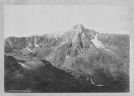
Library of Congress/Courtesy photo
You may have read what I have written before about USGS scientist-trailblazer Ferdinand Hayden or seen his Geologic Atlas of Colorado from 1879. His early history and influence of Colorado in the 1870s, when examined chronologically, adds a sense of the pioneer exuberance and optimism that fueled the settling of places like Aspen.
Hayden, referred to always in Colorado papers as Prof. Hayden, was frequently interviewed and quoted going all the way back to 1866 when the Journal of Mining reported that he, even though there had not yet been a thorough geological survey of the mountains, predicted layers that would contain silver.
In 1867, he was surveying Nebraska, but in 1868, the Colorado Transcript, of Golden City, reported that the government was sending Hayden to do a geological-topographical survey of Wyoming and Colorado and that he would be working along the eastern base of the Rockies until winter set in. In 1869, a prospector brought back and had assayed an ore sample near Georgetown showing $1,200/ton. Silver mines there had a large supply of silver, and he suggested that Golden build a smelter and arrange for timber. There had also been a coal discovery. Hayden, according to the Golden paper, had examined that area “with great care and interest.”
Congress committed to surveying the unknown West and employed several famous explorers/scientists, like Powell and King. Hayden became famous immediately after his survey and reports of Yellowstone in 1872. His important added touch was to employ photographer William Henry Jakson and artist Thomas Moran to show Americans what it looked like. He began work in Colorado, too, at that time; one of the interesting discoveries was in 1872 when his team found fossil turtles “whose shells measured more than 20-feet wide.” They also found an “enormous” mastodon.
During the winter of 1873, after filing reports, Hayden asked for Congress to appropriate $100,000. Powell was exploring the Colorado River (Grand Canyon) at that time and was competing for funding. The Rocky Mountain News stated their opinion: “no wiser expenditure could be made.” He received $20,000.
The summer of 1873, the survey work moved east to higher elevations. There was a fascination by more than one group with the Mount of the Holy Cross that resulted, in the end, by summiting it.
In 1874, the survey was divided into six divisions; they reported back at the end of the summer, highlighting the many high peaks they had set up stations on to do mapping triangulations. The Las Animas Leader had this description: “Dr. Hayden, who has been peaking around through the western portion of our Territory of Colorado peaks — the eye sweeps over a wilderness of high peaks, which can only be equaled in the Andes or Himalayas.”
The Four Corners area was the focus in 1875. They encountered Utes in the beginning, with Chief Ouray, who was upset that they were there because the treaty, two years old, had been broken. The Utes did not want them to proceed. That was worked out, but the survey party rarely encountered them the rest of the summer. One report noted it was “a country of rattlesnakes, lizards, horned toads, and cactus.” They also discovered some of the “remains of an ancient civilization.” The party was also enamored by the deep, rocky, cliff-sided canyons.
The Colorado portion of Hayden’s survey was, after a late start due to Congressional appropriations approval, completed in 1876, mostly working in the Elk Mountains and the San Juans. They climbed every peak, and reports showing conflicting numbers of which peak was tallest in the state sparked local pride.
The most important report concerning Aspen was a geologic summary that identified a mineral zone on both sides of the Elk range; the Leadville side had just begun production of mineral deposits (lead-galena-silver). The atlas and other publications came out in 1877, enticing prospectors to Aspen in 1879.
Hayden’s work — including the extensive mapping, photographs by William Henry Jackson, and artwork by Thomas Moran — showing thousands of square miles of the West captured the interest of the rest of the country.
Tim Willoughby’s family story parallels Aspen’s. He began sharing folklore while teaching at Aspen Country Day School and Colorado Mountain College. Now a tourist in his native town, he views it with historical perspective. Reach him at redmtn2@comcast.net.