Study looks at costs and benefits of 7-mile trail from Redstone to McClure Pass
Forest Service’s Environmental Assessment open for public comment


A proposal for a 7-mile trail from Redstone to McClure Pass would boost access to public lands but chip away at the unique character of the Crystal River Valley, according to a draft environmental assessment prepared by the U.S. Forest Service and released Thursday.
The study by the White River National Forest and outside consultants concluded the trail for nonmotorized uses would provide “substantial benefit to trail connectivity, access, and bike use.” One major benefit would be providing a safe way for people to travel from Redstone to Hayes Creek Falls, a popular natural feature south of the town along Colorado Highway 133.
But the benefits come at a price, the study acknowledged.
“The establishment of a new formalized trail in this area, and the additional public use that it would attract, would negatively impact some community members who prefer undeveloped trail experiences or do not want the perceived or actual impact of increased visitation and increased bike use,” the draft assessment said.
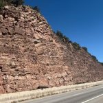
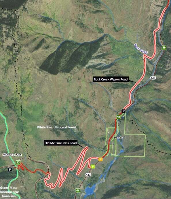
The trail is part of a broader plan by Pitkin County Open Space and Trails, along with Gunnison County, to provide an 83-mile trail from Carbondale to Crested Butte. The Redstone to McClure Pass section would feature 2 miles constructed on the west side of Highway 133 from Redstone to Hayes Creek Falls. At the falls, it would leave the highway corridor and follow a historic wagon road for 1.5 miles through the Bear Creek area, then rejoin the highway corridor at Placita for 0.6 miles. From Placita, the trail would follow the Old McClure Pass Road bed for 2.2 miles, cross beneath Highway 133 in a new pedestrian/bike underpass and continue 0.7 miles to the summit.
About 5 of the 7 miles would be on national forestland, so the Forest Service must review it. Additional approval would be needed from the Colorado Department of Transportation for the stretches in the highway corridor.
The environmental assessment including maps and information about how to comment are available at: FS.usda.gov/project/?project=56913.
The Forest Service will hold a public meeting to answer questions from 5 to 7 p.m. Feb. 7 at Carbondale’s Third Street Center (520 S. Third St.). The public must submit comments by Feb. 22. The agency is asking people to focus on issues raised by the analysis.
Wilderness Workshop, the Roaring Fork Valley’s oldest homegrown environmental group, posted a statement Thursday on Facebook that said its team will be “closely reviewing” the EA. It raised a red flag about expanding recreational trail systems in the region.
“The science is clear that current and increasing recreation is negatively impacting wildlife in our region, and it’s time for our land managers to start scrutinizing those impacts more closely when considering new recreation development,” Wilderness Workshop said.
The assessment was an opportunity for the Forest Service to dive into issues surrounding the trade-offs of expanding recreation on public lands, the statement continued.
“Instead, the Forest Service is taking an overly narrow approach to evaluating this trail that continues the ‘death by a thousand cuts’ outcome that trail development has had on our landscape,” according to the post by Juli Slivka, Wilderness Workshop policy director.
But the assessment indicates the proposed trail would have limited environmental impacts, in large part because it is immediately adjacent to the busy highway or parallels the highway on historic routes that are decommissioned by the Forest Service but still moderately used. The study said the proposed trail would have “negligible new impacts” on elk and suggested the animals might be better off with a formal trail.
As conditions stand, the informal routes on old roads are used year-round. If a formal trail is constructed, it would be closed to all uses from Dec. 1 through April 30 “to protect winter range for elk,” the assessment said. “If calving activity is identified in the Bears Gulch or Lower Old McClure Pass Road areas, closures would be extended to June 30.”
The Forest Service study said building the trail would affect the experience of people already using the decommissioned routes, which may be a point of contention. Nobody likes their favorite, semi-secret route to become a high-profile trail. That would increase use and trigger stricter management.
“Overall, the proposed action would benefit recreational opportunities within the project area by improving trail connectivity, establishing a new mountain bike route and securing long-term access to well-used, non-system trails,” the assessment said. “However, this action could adversely affect some current users of the non-system trails who may be displaced by an increase in overall use or seasonal restrictions.”
Elsewhere, the study states: “The No Action alternative would be consistent with the character of the Crystal River Valley, where rural character, minimal development, and access to nature are valued. Local, informal access and use of the existing non-system trails would continue, which is also consistent with these values and the strong sense of place and community in the (immediate) vicinity, and the preference by some for less developer trail experiences.”
A Forest Service decision on the proposal is expected this spring. The agency will compile and assess public comments in March. It will finalize and potentially modify the environmental assessment in April. A decision notice would be issued in April or May, according to an outline from the agency.
Pitkin County discusses parking availability, traffic at Aspen Airport Business Center
Pitkin County is worried about traffic in the Aspen Airport Business Center.