Emergency projects above Basalt eased Sunday’s flash flood damage

-
Basalt Town Manager Ryan Mahoney on Thursday surveys the catch basin created by Eagle County on the mountainside above the town. Grading directs water into boulder-lined channels which lead to the pond.
Scott Condon/The Aspen Times
-
The catch basin above Pinon Drive in Basalt was full of mud on Monday after the Sunday rainstorm causing flash flooding.
Anna Stonehouse/Special to The Aspen Times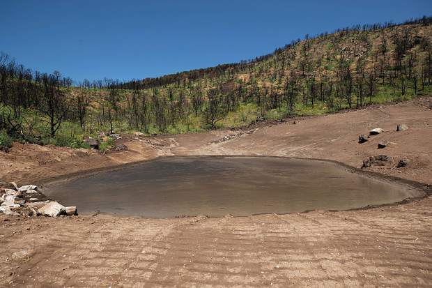
-
The entrance to a culvert was widened and concrete barriers were placed near the intersection of Pinon and Cedar Drive to catch debris. Water overwhelmed the culvert during Sunday's downpour but it still handled a large share of the rain.
Scott Condon/The Aspen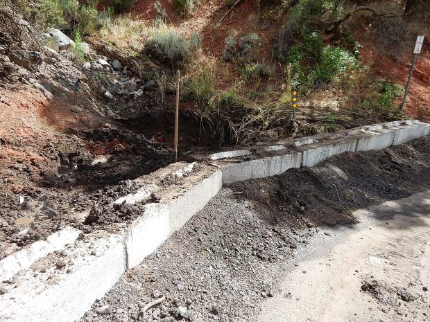
-
-
Sandbags are positioned at the intersection of Pinon and Cedar Drive to divert rainwater later in the monsoon cycle.
Scott Condon/The Aspen Times
-
A water diversion project sent water and mud into a horse pasture and away from structures along Two Rivers Road in Basalt after the Sunday rainstorm causing flash flooding.
Anna Stonehouse/special to The Aspen Times
-
The Basalt town government placed sandbags on Sopris Drive to help divert water from a residence that was affected by Sunday's downpour. The sandbags will remain in place during monsoon season.
Scott Condon/The Aspen Times
-
Patrick Seurynck, right, helps his neighbor Doug McLaughlin clear mud from his driveway on Sopris Drive in Basalt on Monday after the flash flooding from the rainstorm Sunday night.
Anna Stonehouse/special to The Aspen Times
BE PREPARED
When the National Weather Service issues a flash flood warning in the Lake Christine burn scar areas, Pitkin Alert will send out notifications to users who have registered for the weather alerts at http://www.pitkinalert.org. Those who only want to receive information about the threat of flash floods, mudslides and debris flows from the Lake Christine burn scar, can text LCFLOOD to 888777.
A large catch basin that Eagle County sculpted into the mountainside above Basalt in recent weeks prevented significantly more water, mud and debris from swamping part of the Hill District during Sunday’s flash flood, officials said Thursday.
Eagle County Road and Bridge Department used heavy equipment to dig out a settlement pond and then used the dirt removed to regrade the hillside above the Basberg Townhouses. Boulders were placed in two drainage channels that led the water to the settlement pond. While water topped the pond during Sunday’s downpour, a lot of it was captured. Thick, sludge-like water was still in the pond Thursday.
This summer, the town of Basalt also created berms, added curb and gutter and installed a swale to direct water, all just uphill from the Basbergs.
“It was definitely a success,” Roaring Fork Fire Rescue Chief Scott Thompson said of the project.
The work was part of a $1.35 million Emergency Watershed Protection Program project. The federal government supplied a $1.23 million grant through the Natural Resources Conservation Service. The state of Colorado contributed $153,359. Basalt, Eagle County and Colorado Parks and Wildlife are undertaking in-kind projects valued at $153,359, or 12.5%, to cover a local match.
The grant was administered by Basalt. Projects were identified by the Natural Resources Conservation Service. Engineering was provided by SGM, a consultant for Basalt town government.
Basalt Town Manager Ryan Mahoney said about 20% of the work has been completed. Additional projects have been identified above Basalt, on the hillside overlooking Ace Lane’s Tree Farm property in El Jebel and on Basalt Mountain where it drops steeply to Upper Cattle Creek where several historic cabins are located.
Mahoney said he felt work performed at and around a culvert at the intersection of Pinon and Cedar drives in the Hill District also softened the blow of the flash flood.
The town widened the area around the entrance to the culvert but it was still overwhelmed by the amount of water roaring down from a usually dry gulch on the mountain.
“We’ve got some river pigs — big concrete blocks — at the bottom of the drainage,” he said. “Those are to hold debris back.”
Water flowed down Cedar Drive in sheets and diverted into ground where it could. It washed out driveways, rutted roadway shoulders and covered lawns in mud. Water got into at least two homes in the Hill District. Like Thompson, Mahoney said it could have been worse.
“We didn’t have the same volume of water we would have had, had we done nothing,” he said.
While Basalt and Eagle County performed work on public lands, some of the grant money is being used for flood mitigation on private property. A contractor hired by the town was creating a boulder-lined channel for water rolling off the hillside above the Two Rivers Road residence of John and Anne Walker. Although the work wasn’t completed, it worked well enough to divert the water and mud into a horse pasture alongside the road, as intended. Mahoney believes the work probably saved a small horse barn and shed.
The threat of seasonal monsoons adds to the urgency of the projects. Mahoney said the midvalley would benefit for years from the work.
“This isn’t necessarily to just capture this year’s monsoon,” he said.
Eagle County Emergency Manager Birch Barron said the road and bridge department will dredge sediment from the catch basin once it dries enough to maneuver heavy equipment in there.
Basalt and Eagle County officials have been warning for weeks that flash floods and debris flows were a high risk if not a certainty in the Lake Christine Fire burn scar. The fire torched more than 12,500 acres on the lower slopes of Basalt Mountain last summer. Burn scars cannot absorb water as well as natural ground. Runoff didn’t create a problem because of the slow transition to spring and summer, but officials were concerned about the summer monsoon. Sunday’s storm stalled out on the south slopes of Basalt Mountain. The National Weather Service recorded about 1 inch of rain in Basalt and only one-third of an inch in El Jebel. The mountainside above Basalt likely received more.
That much water in a short amount of time is bound to cause problems. Thompson noted that some homes in Elk Run subdivision were hit by water and mud that didn’t come from Basalt Mountain.
“I think some of this would have happened with or without the burn scar,” he said.
Governments teamed to install three rain gauges on Basalt Mountain so the risk of flash flooding can be better assessed in the future. Those rain gauges were calibrated this week to ensure accurate readings.
In addition, National Weather Service meteorologists visited Basalt Mountain with local emergency responders this week to get a better feel for the lay of the land. Thompson said Sunday’s storm demonstrated that different sections of Basalt Mountain can experience vastly different weather.
The projects funded through the Emergency Watershed Protection Program will continue through the summer and into fall. All told, work will be undertaken in nine drainages, Mahoney said.

Cycling Guide 2024: Race around the Roaring Fork Valley
Interested in some of the top mountain biking/cycling events and series around the Roaring Fork Valley? Check out some of these options.


