Colorado transportation officials launch new I-70 land page as a ‘one-stop shop’ for drivers this winter
Drivers who are traveling through the mountains can use COTrip.org or the COTrip Planner app to help plan their trip


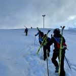
Ryan Spencer/The Aspen Times
The Colorado Department of Transportation has launched a new landing page with information to help drivers plan for trips along the Interstate 70 mountain corridor.
CDOT communications manager Stacia Sellers described driving on the I-70 mountain corridor as “a much different driving experience” than on most other roads, due to the corridor’s high elevation and the potential for extreme weather in the mountains.
That’s why the new landing page, available at CODOT.gov/trave/i70mountain, includes all the information drivers might need to travel along I-70. Sellers suggested that anyone who regularly drives I-70 bookmark the webpage for easy access through the winter.
“It is a resource dedicated to really anything somebody would want to know before and during travel on the corridor,” she said. “It’s a one-stop shop about everything you need to know when driving up the I-70 mountain corridor.”
The landing page includes a link to COTrip.org — Colorado’s official website for real-time road and traffic conditions — with the I-70 mountain corridor preselected and the map automatically showing road conditions, traffic incidents and road work along the route.
The landing page also includes information about Colorado’s chain and traction laws, winter driving safety, travel forecasts, safety metering at the Eisenhower-Johnson Memorial Tunnels and public transit options that are available to the mountains and in the mountains.
“Driving at higher elevations is no joke, it’s much different from driving in the metro area or along the plains of Colorado,” Sellers said. “So expect the unexpected. Always make sure you have a blanket, scrapers, food, water — all in case you do get stuck in a closure.”
Sellers said that anyone planning to travel on the I-70 mountain corridor should familiarize themselves with the information on the new landing page and how to use COTrip.org or the COTrip Planner App, which is available for Android and Apple devices.
Transportation officials at CDOT’s three traffic operation centers — located in Golden, at the Hanging Lake Tunnel and in Pueblo — are constantly updating COTrip with the latest road conditions and closures, Sellers said.
That’s why COTrip is the best way for drivers to stay up to date on any road closures and any official detour routes in the event of a closure. Other mapping services, such as Google Maps or Apple Maps, may not contain accurate information about detours or closures, as they are not updated directly by state transportation officials.
“The reality of driving on I-70 in adverse weather conditions is there’s always a chance that I-70 will close, especially if we’re seeing blizzard-like conditions or we’re seeing lots of spinouts,” Sellers said. “Because that is a reality, it is good to look at COTrip before heading out because you don’t want to get stuck in a closure.”
How to use COTrip.org
Anyone who visits COTrip.org will be greeted with a homepage offering a search function as well as options to “Find a Roadway” or a drop-down menu suggesting “popular routes.” Clicking the “Find a Roadway” option will pull up a map of Colorado’s roads.
On the right-hand side of the screen, a “layers” box lets users choose what is shown on the map. In the winter, the map will default to show road conditions, traffic incidents, a snowplow tracker, weather radar, weather alerts and construction along the route. In the mobile app, the “layers” button is in the bottom-right corner.
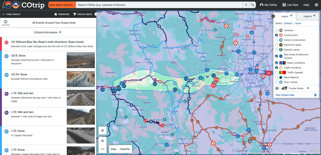
Users can check or uncheck options in the “layers” box to add or remove which alerts appear on the map. For example, selecting the “future construction” option will populate the map with icons showing where future construction projects are planned. Users can then click on individual icons on the map to find out more information about a particular alert.
One of the most helpful layers in the winter is the “road conditions” layer that color codes roads on the map based on the conditions and can tell drivers whether the road is icy, slushy or dry.
Another layer option that drivers may find helpful, especially when roadways are busy, is the “traffic speeds” layer, which color-codes roadways based on traffic flow, with green indicating fast-flowing traffic and red indicating standstill traffic.
The “plow tracker” layer shows drivers where CDOT’s snowplows are on the map.
For those road tripping in Colorado, the “Scenic Byways” layer highlights some of the state’s most scenic roadways and the “Rest Areas” layer can help travelers locate good places to stop for a break or where to safely pull off the road in the event of a closure.
Another popular feature is the “Cameras” layer, which displays all of CDOT’s traffic cameras across the state. Users can click an individual camera icon on the map to view the most recent footage from that camera, which can give drivers a sense of the conditions and traffic levels on a particular roadway. The new I-70 mountain corridor landing page also includes a link to COTrip.org, which preselects the cameras along the corridor.
To keep up to date with alerts while driving, users can click the speaker icon in the top-right corner of the COTrip Planner App. This will enable voice-announced traffic reports as the driver approaches them, allowing the driver to stay up to date on alerts while complying with the state’s hands-free law, which bans drivers from holding electronic devices.
Searching in COTrip
Users can also use the search function on COTrip to find information about a roadway or a particular camera. As a user types in a search, a drop-down menu will appear with suggested search options. For example, searching for “Interstate 70” will highlight the I-70 corridor, allowing users to explore cameras along the route and view alerts about closures or road construction.
By choosing the “Custom Route” search option, travelers can input a starting and ending address and COTrip will plot out the route between those two points, highlighting traffic incidents or roadwork along the way.
When a route is chosen, COTrip will estimate the expected current travel time and display Google’s estimate of how many minutes delay a driver could expect along the route.
My COTrip
By creating a “My COTrip” account, travelers can sign up to receive text and email alerts, save favorite routes, and customize when they receive alerts for those roadways.
After logging in, users can click on “My COTrip” and navigate to “Edit Alerts” where they can choose how frequently they receive alerts, with options to receive “Critical” alerts, “Urgent” alerts or “Routine” alerts.
Users can also “favorite” routes they frequent for easy access and to receive alerts specific to that route. To save a route, a user simply has to search the route or choose a particular roadway, select the layers they want to see and click the heart-shaped “favorite” button.
After clicking the “favorite” button, a window will pop up, allowing the user to label the route with a custom name and choose whether to receive email or text alerts for the route. Users can also customize what days of the week they would like to receive alerts.
When favoriting a route, users can also set “travel time warnings” to receive an alert when the travel time exceeds a specified amount. For example, a commuter traveling between Breckenridge and Denver could set the travel time warning for two hours, so they’ll be notified if the travel time along that route exceeds two hours.